No products in the cart.: $0.00

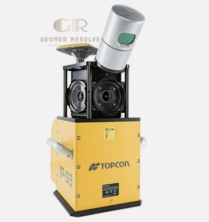
Topcon IP-S3 HD1 3D Mobile Mapping System
The Topcon IP-S3 HD1 3D Mobile Mapping System is a professional LiDAR & Laser Scanning Equipment solution designed for high-speed mobile surveying, GIS mapping, transportation infrastructure documentation, smart city projects, and large-scale 3D reality capture. Combining a 700,000 points-per-second LiDAR scanner, 226-channel GNSS receiver, high-performance IMU, and a six-camera panoramic imaging system, the IP-S3 HD1 delivers highly accurate georeferenced point clouds and panoramic imagery while driving at normal traffic speeds. Fully compatible with Mobile Master Office, Mobile Master Field, and MAGNET Collage, the system provides an efficient workflow for data collection, processing, and visualization.
Description
Topcon IP-S3 HD1 3D Mobile Mapping System – High-Density Vehicle-Mounted LiDAR Mapping Solution
The Topcon IP-S3 HD1 3D Mobile Mapping System is a high-performance LiDAR & Laser Scanning Equipment solution engineered for professional mobile mapping and large-scale infrastructure surveying. Combining a 700,000 points-per-second LiDAR scanner, 226-channel GNSS receiver, precision IMU, wheel encoder, and a six-camera panoramic imaging system, it captures dense, georeferenced point clouds and high-resolution 360-degree imagery while vehicles travel at normal road speeds. This integrated approach significantly improves field productivity while maintaining survey-grade accuracy.
Compatible with Mobile Master Field, Mobile Master Office, and MAGNET Collage, the IP-S3 HD1 provides a complete workflow from field acquisition to point cloud processing, trajectory correction, feature extraction, and GIS/CAD integration. Its compact design, rugged construction, and reliable performance make it ideal for transportation surveys, smart city development, highway engineering, infrastructure inspection, utility mapping, and digital asset management.
The Topcon IP-S3 HD1 3D Mobile Mapping System is an excellent solution for surveying companies, transportation authorities, civil engineering firms, GIS professionals, utility providers, and government agencies seeking a professional vehicle-mounted mobile LiDAR mapping system.
Main Benefits
High-Density Mobile LiDAR Scanning
Captures up to 700,000 points per second for dense, detailed 3D point clouds.
Fast Mobile Data Collection
Collects accurate mapping data while traveling at normal driving speeds, minimizing field time.
Integrated Positioning System
Combines GNSS, IMU, and wheel encoder technologies for accurate positioning and trajectory calculation.
High-Resolution Panoramic Imaging
Six synchronized CCD cameras generate panoramic images with up to 8000 × 4000 pixel resolution.
Survey-Grade Accuracy
Provides approximately 50 mm absolute coordinate accuracy and 10 mm road surface accuracy under specified conditions.
Complete Mapping Workflow
Works seamlessly with Mobile Master software for trajectory processing, point cloud editing, feature extraction, and GIS/CAD export.
Key Features
High-Speed LiDAR Scanner
Measurement Rate: 700,000 points/sec
Maximum Range: 100 m
for rapid and accurate mobile mapping.
226-Channel GNSS Receiver
Supports:
GPS L1/L2
GLONASS L1/L2
with 10 Hz positioning updates.
Precision IMU
Provides:
Gyro Bias Stability: 1°/hr
Acceleration Bias Stability: 7.5 mg
for reliable trajectory estimation.
Six-Camera Panoramic Imaging
Captures:
360° panoramic images
Six CCD cameras
Up to 8000 × 4000 pixels
Up to 10 fps
for detailed visual documentation.
Vehicle-Mounted Design
Compact and lightweight sensor unit allows quick installation on cars, SUVs, and survey vehicles.
Mobile Master Software
Compatible with:
Mobile Master Field (MMF)
Mobile Master Office (MMO)
MAGNET Collage
for data acquisition, processing, visualization, and export.
Factory-Calibrated System
Integrated hardware calibration provides reliable measurement accuracy.
Rugged Outdoor Construction
Designed for continuous operation in demanding surveying and infrastructure environments.
Specifications
Product Type: Vehicle-Mounted 3D Mobile Mapping System
Category: LiDAR & Laser Scanning Equipment
Subcategory: Mobile LiDAR Mapping Systems
Manufacturer: Topcon Positioning Systems
Model: IP-S3 HD1
Scanning Technology
Vehicle-Mounted LiDAR
Mobile Mapping System
LiDAR Measurement Rate
700,000 points/second
Maximum Measurement Range
100 m
GNSS Receiver
226 Channels
GPS L1/L2
GLONASS L1/L2
10 Hz Update Rate
Static Accuracy
Horizontal: ±3 mm + 0.5 ppm
Vertical: ±3 mm + 0.5 ppm
Kinematic Accuracy
Horizontal: ±10 mm + 1 ppm
Vertical: ±15 mm + 1 ppm
System Accuracy
Absolute Coordinate Accuracy: 50 mm (1 Sigma)
Surface Accuracy: 10 mm (1 Sigma)
IMU
Gyro Bias Stability: 1°/hr
Acceleration Bias Stability: 7.5 mg
Camera System
Six CCD Cameras
360° Panoramic Imaging
Maximum Resolution: 8000 × 4000 pixels
Maximum Capture Speed: 10 fps
Wheel Encoder
2500 PPR
Protection Rating
Sensor Components: IP67
Timing Box: IP65
Power Supply
9–36 VDC
Operating Time
Up to 8 Hours
Software Compatibility
Mobile Master Field
Mobile Master Office
MAGNET Collage
Applications
Mobile Mapping
GIS Data Collection
Transportation Surveying
Highway Mapping
Smart City Mapping
Infrastructure Inspection
Asset Management
Utility Mapping
Recommended Industries
Surveying
Civil Engineering
Transportation
GIS
Government Agencies
Utility Companies
Smart City Development
Infrastructure Management
Applications
Highway Surveying
Rapidly captures high-density road corridor data for engineering and maintenance.
GIS Mapping
Generates georeferenced point clouds and panoramic imagery for GIS databases.
Smart City Projects
Supports urban digital twin creation and city infrastructure documentation.
Transportation Infrastructure
Documents roads, bridges, railways, and transportation assets.
Utility Mapping
Captures utility corridors and roadside infrastructure efficiently.
Asset Management
Creates detailed inventories of transportation and municipal assets.
Engineering Surveys
Provides accurate 3D data for planning, design, and construction projects.
What is the Topcon IP-S3 HD1?
The Topcon IP-S3 HD1 is a professional vehicle-mounted mobile mapping system that combines LiDAR, GNSS, IMU, and panoramic imaging for high-speed 3D data collection.
How fast does the LiDAR scanner collect data?
The system captures up to 700,000 points per second, producing dense and accurate point clouds.
What positioning technologies are included?
It integrates a 226-channel GNSS receiver, IMU, and wheel encoder for accurate positioning and trajectory computation.
What camera system does the IP-S3 HD1 use?
It features six CCD cameras that produce 360-degree panoramic images with resolutions up to 8000 × 4000 pixels.
Which software supports the IP-S3 HD1?
The system is compatible with Mobile Master Field, Mobile Master Office, and MAGNET Collage for acquisition, processing, visualization, and export.
Who commonly uses the Topcon IP-S3 HD1?
It is widely used by surveyors, civil engineers, GIS professionals, transportation agencies, utility companies, infrastructure consultants, and mapping service providers.