
No products in the cart.: $0.00


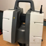
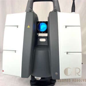
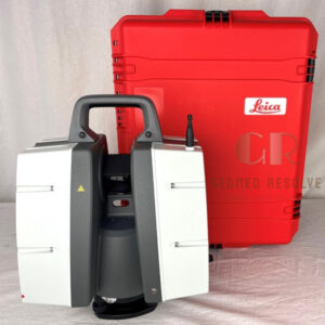
Leica ScanStation P40 Laser Scanner
Capture highly accurate long-range 3D measurements and detailed point clouds for professional surveying, engineering, and reality capture projects
Description
Leica ScanStation P40 Laser Scanner | High-Accuracy Long-Range 3D Laser Scanning System
The Leica ScanStation P40 Laser Scanner is a professional long-range 3D laser scanning solution designed for high-precision surveying, reality capture, industrial documentation, infrastructure mapping, and BIM applications. Built to perform in demanding environments, the P40 delivers highly accurate point cloud data and detailed 3D models for engineering, construction, and geospatial projects.
Key Features
High-precision long-range 3D laser scanning
Advanced LiDAR measurement technology
Exceptional point cloud accuracy
Fast and efficient data acquisition
Long-range scanning performance
Suitable for indoor and outdoor environments
Supports BIM and digital twin workflows
Reliable operation in challenging field conditions
Professional-grade surveying capabilities
Designed for infrastructure and industrial projects
Specifications
Product Type: Terrestrial 3D Laser Scanner
Technology: LiDAR Laser Scanning
Scanning Method: Static terrestrial scanning
Data Output: High-density point clouds and 3D models
Range Capability: Long-range scanning performance
Applications: Surveying, engineering, construction, and industrial documentation
Industry Use: AEC, mining, infrastructure, utilities, and geospatial projects
Applications
Reality capture
Topographic surveying
BIM documentation
Digital twin creation
Infrastructure mapping
Industrial plant documentation
Construction verification
Tunnel and mining surveys
Facility management
Engineering and geospatial projects
Why Choose Leica ScanStation P40 Laser Scanner?
The Leica ScanStation P40 is trusted by surveying and engineering professionals worldwide for its exceptional accuracy, long-range capabilities, and dependable performance. It is an ideal solution for projects requiring precise reality capture, comprehensive documentation, and reliable geospatial data collection.

There are no reviews yet.