
No products in the cart.: $0.00


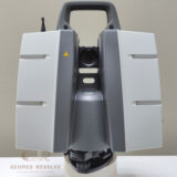
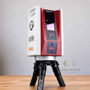
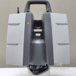
Leica ScanStation P30 Laser Scanner
Capture precise long-range 3D measurements and detailed point clouds for surveying, construction, and reality capture projects with industry-proven Leica technology
Description
Leica ScanStation P30 Laser Scanner | Professional Long-Range 3D Laser Scanning System for Surveying & Reality Capture
The Leica ScanStation P30 Laser Scanner is a professional-grade terrestrial 3D laser scanner designed for accurate reality capture, surveying, construction documentation, BIM workflows, and industrial measurement applications. Equipped with advanced LiDAR technology, the P30 delivers reliable long-range scanning, dense point cloud generation, and high-quality 3D data for engineering and geospatial projects.
Key Features
High-accuracy terrestrial laser scanning
Advanced LiDAR-based measurement technology
Long-range scanning performance
Fast point cloud data acquisition
High-density 3D data capture
Reliable operation in indoor and outdoor environments
Supports BIM and digital twin workflows
Rugged design for demanding field conditions
Efficient surveying and documentation processes
Ideal for engineering and infrastructure projects
Specifications
Product Type: Terrestrial 3D Laser Scanner
Technology: LiDAR Laser Scanning
Scanning Method: Static laser scanning
Data Output: Point clouds, 3D models, and digital documentation
Range Capability: Professional long-range scanning
Operation: Surveying and reality capture workflows
Applications: Construction, engineering, industrial documentation, and geospatial mapping
Applications
Reality capture
Land and engineering surveys
BIM documentation
Digital twin creation
Infrastructure mapping
Construction verification
Industrial plant documentation
Facility management
Topographic mapping
Geospatial data collection
Why Choose Leica ScanStation P30 Laser Scanner?
The Leica ScanStation P30 is a trusted solution for professionals who require dependable 3D scanning performance, accurate measurements, and efficient data collection. Its robust design and high-quality LiDAR technology make it ideal for surveying, engineering, and construction projects that demand reliable reality capture results.
There are no reviews yet.