
No products in the cart.: $0.00

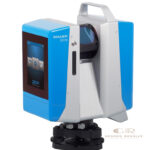
Z+F IMAGER 5016 3D Laser Scanner
The Z+F IMAGER 5016 Laser Scanner is a high-performance 3D scanning system designed for fast, accurate, and detailed reality capture in industrial, surveying, engineering, and documentation applications. Combining advanced laser scanning technology with high measurement speed and precision, the IMAGER 5016 captures detailed 3D point clouds for creating accurate digital models of real-world environments
Description
Z+F IMAGER 5016 Laser Scanner – High Precision 3D Laser Scanning Equipment
The Z+F IMAGER 5016 3D Laser Scanner is a professional 3D Scanners solution designed for accurate reality capture and detailed spatial documentation. Using advanced terrestrial laser scanning technology, the IMAGER 5016 captures precise 3D point cloud data for engineering, surveying, construction, and industrial applications.
This high-performance laser scanner enables professionals to digitally record complex environments, structures, and objects with speed and accuracy. The collected data can support BIM modeling, CAD workflows, inspection projects, facility management, and digital preservation.
With reliable measurement performance, efficient scanning capability, and professional-grade accuracy, the Z+F IMAGER 5016 provides an effective solution for organizations requiring precise 3D documentation and reality capture.
Main Benefits
High-Precision 3D Data Capture
Captures accurate point cloud data for detailed digital representation of physical environments.
Fast Laser Scanning Performance
Provides efficient data collection for large-scale surveying and documentation projects.
Reliable Measurement Accuracy
Delivers precise spatial information for engineering, construction, and industrial applications.
Improves Surveying Efficiency
Reduces fieldwork time by quickly capturing complex structures and environments.
Professional Reality Capture Solution
Supports advanced 3D modeling, inspection, and digital documentation workflows.
Key Features
Advanced Terrestrial Laser Scanning Technology
Uses precise laser measurement technology to capture detailed 3D point clouds of objects and environments.
High-Speed Data Acquisition
Designed for efficient scanning of large areas while maintaining measurement accuracy.
Detailed 3D Point Cloud Generation
Creates accurate digital datasets for CAD, BIM, GIS, and engineering workflows.
Integrated Imaging Capability
Supports realistic visualization and documentation through high-quality scan data and imagery.
Compact Professional Design
Provides portability and flexibility for indoor and outdoor scanning projects.
Wide Range of Professional Applications
Suitable for architecture, construction, industrial measurement, surveying, and forensic documentation.
Specifications
Product Type: Terrestrial 3D Laser Scanner
Technology: Laser-based 3D reality capture
Measurement Method: Time-of-Flight laser scanning
Output Data: 3D point clouds and digital documentation data
Applications: Surveying, BIM, industrial inspection, architecture, and mapping
Scanning Mode: Static terrestrial laser scanning
Accuracy: High-precision spatial measurement capability
Operation: Portable field scanning system
Data Processing: Compatible with professional 3D processing workflows
Design: Rugged equipment for professional surveying environments
Applications
Building Documentation
Used to capture accurate 3D data of buildings, structures, and architectural environments.
BIM and Construction Projects
Supports Building Information Modeling workflows with detailed reality capture data.
Industrial Plant Measurement
Helps document factories, facilities, and complex industrial environments.
Surveying and Mapping
Provides precise spatial data for land surveys, engineering projects, and infrastructure documentation.
Cultural Heritage Preservation
Used for digital recording and preservation of historical structures and sites.
Forensic Investigation
Supports accident reconstruction and detailed scene documentation.
What is the Z+F IMAGER 5016 used for?
The Z+F IMAGER 5016 is used for professional 3D laser scanning, reality capture, surveying, engineering documentation, and industrial measurement.
What type of data does the scanner produce?
It produces high-precision 3D point clouds that can be processed into digital models, CAD drawings, and BIM documentation.
Is the Z+F IMAGER 5016 suitable for outdoor scanning?
Yes. It is designed for professional indoor and outdoor terrestrial laser scanning applications.
Who uses the Z+F IMAGER 5016?
It is commonly used by surveyors, engineers, architects, construction professionals, industrial inspectors, and mapping specialists.
What industries benefit from 3D laser scanning?
Industries including construction, architecture, manufacturing, infrastructure, energy, and cultural heritage benefit from accurate 3D scanning technology.
How does 3D laser scanning improve projects?
It provides fast and accurate digital measurements, reducing manual surveying time and improving project accuracy.
There are no reviews yet.