
No products in the cart.: $0.00


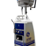
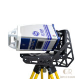
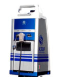
STONEX X300 3D Laser Scanner
High-accuracy 3D scanning for professional surveying
Fast data capture for improved productivity
Produces dense and detailed point clouds
Reduces field measurement time and rework
Suitable for indoor and outdoor environments
Supports BIM and digital twin workflows
Improves documentation accuracy and efficiency
Description
STONEX X300 3D Laser Scanner
The STONEX X300 3D Laser Scanner is a high-precision terrestrial laser scanning system designed for fast, accurate, and detailed 3D data capture. Built for surveying, construction, engineering, and industrial applications, the X300 delivers reliable point cloud generation for reality capture, as-built documentation, and spatial analysis. Its robust design and advanced LiDAR technology make it a dependable solution for professionals who require high-quality 3D measurement data in the field.
Key Features
Advanced terrestrial LiDAR scanning technology
High-speed 3D point cloud acquisition
Long-range scanning capability
Integrated imaging system for colorized point clouds
Real-time data visualization
Rugged industrial-grade design
Portable field deployment setup
Efficient workflow and data processing
User-friendly operation interface
Compatible with standard surveying software
Specifications
Model: STONEX X300
Technology: Terrestrial 3D Laser Scanning (LiDAR)
Type: Stationary 3D Laser Scanner
Data Output: High-density 3D point clouds
Imaging: Integrated color capture system
Operation: Field-based scanning system
Scanning Range: Long-range terrestrial measurement
Environment: Indoor and outdoor applications
Workflow: Data acquisition and post-processing
Applications
3D reality capture
Land surveying
Construction documentation
As-built surveys
Building information modeling (BIM)
Infrastructure mapping
Industrial facility scanning
Heritage documentation
Engineering measurement
Topographic mapping
Why Choose the STONEX X300?
The STONEX X300 offers a powerful combination of speed, accuracy, and reliability for professional 3D laser scanning. It enables surveyors and engineers to capture precise spatial data efficiently, making it ideal for demanding projects that require high-quality documentation and measurement accuracy.


There are no reviews yet.