
No products in the cart.: $0.00


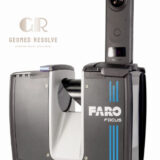
Faro Focus Premium Max 400M with 360 Pano Camera
High-accuracy 3D reality capture
Long-range scanning for large projects
Integrated 360° panoramic documentation
Fast field data collection
Reduces measurement errors and rework
Supports digital twin and BIM workflows
Improves project efficiency and productivity
Description
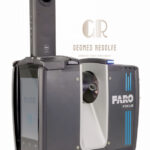
Faro Focus Premium Max 400M with 360 Pano Camera
The Faro Focus Premium Max 400M with 360 Pano Camera is a professional-grade terrestrial laser scanning system designed for long-range reality capture, surveying, mapping, and digital documentation. Combining high-accuracy 3D laser scanning with immersive 360° panoramic imaging, this advanced solution delivers detailed point clouds and high-quality visual data for construction, engineering, geospatial, forensic, and industrial applications.
Key Features
Advanced terrestrial laser scanning technology
Maximum scanning range up to 400 meters
Integrated 360° panoramic camera
High-density point cloud generation
High-speed scan acquisition
HDR imaging capabilities
Wireless connectivity and remote operation
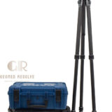
Compact and portable design
Rugged construction for field environments
Seamless integration with Faro software solutions
Specifications
Model: Faro Focus Premium Max 400M
Technology: Terrestrial 3D Laser Scanner
Maximum Range: Up to 400 m
Imaging System: Integrated 360° Pano Camera
Data Output: High-resolution point clouds and panoramic imagery
Connectivity: Wireless and data transfer capabilities
Operation: Portable field scanning system
Application Environment: Indoor and outdoor surveying
Software Compatibility: Faro reality capture and processing software
Applications
3D reality capture
Land surveying
Construction documentation
Building information modeling (BIM)
As-built surveys
Infrastructure mapping
Industrial facility documentation
Digital twin creation
Forensic investigation
Heritage preservation
Why Choose the Faro Focus Premium Max 400M?
The Faro Focus Premium Max 400M combines long-range laser scanning performance with immersive 360° imaging, enabling professionals to capture accurate spatial data and visual context in a single workflow. Its powerful capabilities make it an ideal solution for large-scale surveying, engineering, and reality capture projects.
There are no reviews yet.