
No products in the cart.: $0.00


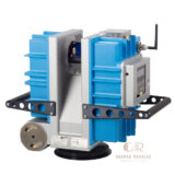
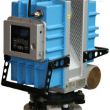
Z+F IMAGER 5006EX 3D Laser Scanner
The Z+F IMAGER 5006EX 3D Laser Scanner is a professional terrestrial laser scanning system designed for accurate 3D reality capture in industrial, surveying, engineering, and complex environment documentation applications. Featuring advanced laser measurement technology and a robust design, the IMAGER 5006EX captures detailed 3D point clouds for creating precise digital models of structures, facilities, and environments.
Description
Z+F IMAGER 5006EX 3D Laser Scanner – High Precision Terrestrial Laser Scanning System
The Z+F IMAGER 5006EX 3D Laser Scanner is a professional 3D Scanners solution designed for high-precision reality capture and advanced spatial documentation. With powerful laser scanning technology, this system captures accurate 3D point cloud data for industrial measurement, surveying, construction, engineering, and facility documentation.
The IMAGER 5006EX helps professionals digitally capture complex environments, machinery, structures, and infrastructure with speed and accuracy. Its reliable performance makes it suitable for applications including BIM modeling, industrial plant documentation, architectural recording, and engineering analysis.
With high-quality scanning capability, professional durability, and efficient data collection, the Z+F IMAGER 5006EX provides a trusted solution for organizations requiring accurate 3D measurement and digital reality capture.
Main Benefits
High-Accuracy 3D Data Capture
Provides precise laser scanning results for detailed measurement and digital documentation.
Professional Industrial Performance
Designed for demanding environments where reliable and accurate 3D scanning is required.
Efficient Reality Capture
Quickly captures large and complex areas, reducing manual measurement time.
Detailed Point Cloud Generation
Creates accurate 3D datasets for CAD, BIM, engineering, and inspection workflows.
Flexible Field Applications
Suitable for indoor and outdoor scanning projects across multiple industries.
Key Features
Advanced Terrestrial Laser Scanning Technology
Uses high-performance laser measurement technology to capture detailed 3D spatial information.
High Resolution Point Cloud Data
Generates accurate digital representations of buildings, equipment, and environments.
Long-Range Scanning Capability
Designed for capturing large areas and complex structures efficiently.
Integrated Digital Documentation
Supports professional workflows for surveying, engineering, and 3D modeling.
Rugged Professional Design
Built for reliable operation in industrial and field environments.
Suitable for Complex Environments
Ideal for factories, plants, infrastructure, construction sites, and large facilities.
Specifications
Product Type: Terrestrial 3D Laser Scanner
Technology: Laser-based 3D reality capture
Measurement Method: Phase-based laser scanning technology
Output Data: High-density 3D point clouds
Scanning Application: Indoor and outdoor spatial documentation
Data Compatibility: Supports professional CAD, BIM, and 3D processing workflows
Operation: Portable tripod-mounted scanning system
Accuracy: High-precision measurement for professional surveying applications
Primary Uses: Industrial measurement, construction documentation, surveying, and inspection
Design: Rugged scanner for professional field operation
Applications
Industrial Plant Documentation
Used to capture detailed 3D data of factories, production facilities, and complex industrial environments.
Construction and BIM Projects
Supports accurate building documentation, renovation planning, and BIM model creation.
Surveying and Engineering
Provides reliable spatial measurements for engineering surveys and infrastructure projects.
Architecture and Heritage Documentation
Helps create detailed digital records of buildings, structures, and historical sites.
Industrial Inspection
Supports dimensional verification and analysis of equipment, facilities, and mechanical installations.
Forensic and Accident Documentation
Provides accurate 3D scene recording for investigation and analysis purposes.
What is the Z+F IMAGER 5006EX used for?
The Z+F IMAGER 5006EX is used for professional 3D laser scanning, reality capture, surveying, industrial documentation, and engineering applications.
What data does the IMAGER 5006EX produce?
It produces detailed 3D point cloud data that can be processed into digital models, CAD drawings, and BIM documentation.
Is the Z+F IMAGER 5006EX suitable for industrial environments?
Yes. It is designed for professional applications requiring accurate measurement in complex industrial and engineering environments.
Can this scanner be used for construction projects?
Yes. It supports construction documentation, renovation planning, and BIM workflows.
What industries use 3D laser scanners like the IMAGER 5006EX?
Common industries include construction, manufacturing, surveying, architecture, engineering, infrastructure, and industrial inspection.
What are the advantages of using a 3D laser scanner?
3D laser scanners provide fast, accurate, and detailed digital measurements while reducing manual surveying effort.

There are no reviews yet.