
No products in the cart.: $0.00


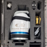
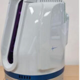

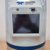
Teledyne Optech Polaris HR
Capture highly accurate long-range 3D data with advanced LiDAR technology designed for large-scale surveying, mapping, and reality capture projects
Description
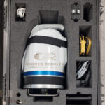
Teledyne Optech Polaris HR | High-Resolution Long-Range 3D Laser Scanner for Surveying & Reality Capture Used
The Teledyne Optech Polaris HR is a high-performance long-range 3D laser scanner engineered for precision surveying, reality capture, infrastructure mapping, mining, and industrial documentation. Utilizing advanced LiDAR technology, the Polaris HR delivers exceptional accuracy, high-density point clouds, and reliable long-range scanning performance for demanding professional applications.
Key Features
High-resolution long-range laser scanning
Advanced LiDAR technology
Exceptional accuracy and measurement reliability
High-density point cloud generation
Suitable for large-scale projects and environments
Fast data acquisition and processing
Supports BIM and digital twin workflows
Designed for industrial and surveying applications
Rugged field-ready construction
Efficient reality capture and mapping solution
Specifications
Product Type: Long-Range 3D Laser Scanner
Technology: LiDAR Laser Scanning
Scanning Method: Terrestrial laser scanning
Data Output: Point clouds, 3D models, and geospatial datasets
Range Capability: Long-range professional scanning
Operation: Static and field-based surveying workflows
Applications: Surveying, infrastructure mapping, mining, engineering, and reality capture
Applications
Reality capture
Topographic surveying
Infrastructure mapping
Mining surveys
BIM documentation
Digital twin creation
Industrial plant documentation
Engineering surveys
Construction verification
Geospatial data collection
Why Choose Teledyne Optech Polaris HR?
The Teledyne Optech Polaris HR is designed for professionals who require long-range performance, high accuracy, and reliable LiDAR data collection. Its advanced scanning capabilities make it an ideal solution for surveying firms, engineering companies, infrastructure projects, and industrial environments where precision is critical.

There are no reviews yet.