
No products in the cart.: $0.00


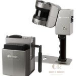
STONEX XH120 SLAM 3D Scanner
Fast and efficient 3D data capture
Accurate mapping in GNSS-denied environments
Portable and easy to operate in the field
Reduces survey time and operational costs
Produces high-density point cloud data
Supports BIM and digital twin workflows
Enhances productivity in complex environments
Description
STONEX XH120 SLAM 3D Scanner
The STONEX XH120 SLAM 3D Scanner is a high-performance mobile mapping and reality capture system designed for fast, accurate 3D scanning in indoor and outdoor environments. Powered by advanced SLAM technology, the XH120 captures dense point cloud data without GNSS dependency, making it ideal for complex environments such as buildings, tunnels, industrial facilities, and construction sites. It delivers efficient, portable, and reliable 3D data collection for surveying, engineering, and BIM workflows.
Key Features
Advanced SLAM-based 3D scanning technology
Real-time positioning and mapping
High-density point cloud generation
Portable handheld or mobile scanning system
Indoor and outdoor scanning capability
Lightweight and ergonomic design
Efficient post-processing workflow
High-speed data acquisition
Compatible with standard point cloud software
Designed for professional surveying applications
Specifications
Model: STONEX XH120
Technology: SLAM (Simultaneous Localization and Mapping)
Type: Mobile 3D Laser Scanner
Data Output: High-density 3D point clouds
Operation: Handheld mobile mapping system
Positioning: SLAM-based navigation system
Scanning Environment: Indoor and outdoor use
Workflow: Real-time data capture and processing
Application: Surveying, mapping, and reality capture
Applications
Mobile mapping
3D reality capture
Indoor and building surveys
Construction documentation
As-built surveys
BIM data collection
Industrial facility mapping
Tunnel and underground mapping
Infrastructure documentation
Digital twin creation
Why Choose the STONEX XH120 SLAM 3D Scanner?
The STONEX XH120 offers fast, reliable, and highly mobile 3D scanning performance for professionals working in complex environments. Its SLAM technology enables accurate data capture without GNSS signals, making it a powerful solution for indoor mapping, construction documentation, and advanced surveying projects.

There are no reviews yet.