
No products in the cart.: $0.00


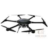
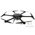
Satlab SLL3 Aerial Drone Multicopter
Efficient aerial data collection
High-precision surveying and mapping capabilities
Stable flight performance for reliable results
Reduces fieldwork time and operational costs
Supports large-area coverage in a single mission
Flexible payload integration for various applications
Improves productivity and project efficiency
Description
Satlab SLL3 Aerial Drone Multicopter
The Satlab SLL3 Aerial Drone Multicopter is a professional unmanned aerial vehicle (UAV) designed for aerial surveying, mapping, inspection, and geospatial data collection. Built for reliability and efficiency, the SLL3 combines stable flight performance, advanced navigation technology, and flexible payload integration to support demanding surveying and mapping projects. It is an ideal solution for land surveyors, engineering firms, construction professionals, and geospatial service providers.
Key Features
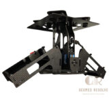
Professional multicopter UAV platform
High-stability flight control system
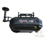
Advanced GNSS navigation technology
Automated flight planning and mission execution
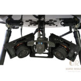
Compatible with mapping and surveying payloads
Real-time flight monitoring
Lightweight and durable construction
Portable design for field deployment
Long-endurance flight capability
Designed for professional geospatial applications
Specifications
Model: Satlab SLL3
Type: Aerial Drone Multicopter
Platform: Professional UAV System
Navigation: GNSS-Based Positioning
Flight Control: Automated and manual flight modes
Payload Support: Surveying and mapping sensors
Operation: Remote-controlled aerial platform
Application Environment: Outdoor surveying and inspection
Data Collection: Aerial imagery and geospatial data acquisition
Applications
Aerial surveying
Topographic mapping
Land surveying
Construction monitoring
Infrastructure inspection
Corridor mapping
Mining surveys
Agricultural mapping
Environmental monitoring
Geospatial data collection
Why Choose the Satlab SLL3?
The Satlab SLL3 delivers reliable flight performance and professional-grade aerial data acquisition for surveying and mapping professionals. Its efficient workflow, stable operation, and compatibility with advanced survey sensors make it a valuable tool for capturing accurate geospatial information quickly and safely.
There are no reviews yet.