
No products in the cart.: $0.00


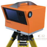
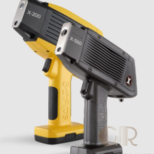
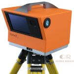
Optech ILRIS Terrestrial Laser Scanner
The Optech ILRIS Terrestrial Laser Scanner is a professional long-range 3D LiDAR scanning system designed for accurate spatial data capture in surveying, engineering, mining, infrastructure, and environmental applications. Using advanced laser ranging technology, the ILRIS scanner collects detailed 3D point cloud data for mapping, monitoring, and analysis of large-scale environments and complex structures.
Description
Optech ILRIS Terrestrial Laser Scanner – Long Range 3D LiDAR Scanning System
The Optech ILRIS Terrestrial Laser Scanner is a professional LiDAR & Laser Scanning Equipment solution designed for high-accuracy, long-range 3D reality capture. Utilizing advanced LiDAR technology, the ILRIS scanner collects detailed point cloud data for surveying, engineering, mining, infrastructure inspection, and environmental applications.
With its long-distance measurement capability and reliable field performance, the Optech ILRIS enables professionals to digitally capture large-scale environments, complex structures, and challenging terrain. The collected 3D data supports CAD modeling, GIS applications, engineering analysis, and project documentation.
Designed for organizations requiring precise and efficient spatial measurement, the Optech ILRIS Terrestrial Laser Scanner provides a dependable solution for professional 3D mapping and reality capture projects.
Main Benefits
Long-Range 3D Laser Scanning
Captures detailed 3D measurements from long distances, making it suitable for large-scale surveying and monitoring projects.
High-Accuracy Spatial Data
Provides precise point cloud information for engineering, mapping, and inspection applications.
Efficient Field Data Collection
Reduces manual measurement time by quickly capturing complex environments.
Reliable Outdoor Performance
Designed for professional use in challenging environments including mining, construction, and infrastructure sites.
Supports Digital Modeling Workflows
Provides accurate 3D data for CAD, GIS, engineering analysis, and visualization projects.
Key Features
Advanced LiDAR Measurement Technology
Uses laser ranging technology to collect accurate distance measurements and create detailed 3D point clouds.
Long-Distance Scanning Capability
Designed for applications requiring measurement of large areas, terrain, structures, and remote objects.
High-Resolution 3D Data Capture
Captures detailed spatial information for professional mapping and analysis.
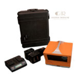
Portable Field Design
Provides flexibility for surveying teams working in different locations and environments.
Suitable for Complex Environments
Ideal for mining sites, industrial facilities, natural terrain, and infrastructure projects.
Professional Data Processing Support
Works with specialized software workflows for visualization, modeling, and measurement analysis.
Specifications
Product Type: Terrestrial Laser Scanner
Technology: LiDAR (Light Detection and Ranging)
Measurement Method: Laser time-of-flight distance measurement
Output Data: 3D point clouds and spatial measurement data
Scanning Application: Long-range terrestrial scanning
Primary Uses: Surveying, mining, engineering, mapping, and monitoring
Data Processing: Compatible with professional 3D point cloud software
Operation: Tripod-mounted field scanning system
Environment: Outdoor and industrial applications
Design: Portable professional laser scanning equipment
Applications
Mining and Quarry Surveying
Used for capturing terrain, excavation areas, stockpiles, and mining environments with accurate 3D measurements.
Infrastructure Inspection
Supports documentation and monitoring of bridges, dams, tunnels, and large structures.
Engineering and Construction
Provides accurate site measurements for planning, design, and project documentation.
Topographic Mapping
Used to collect detailed terrain information for surveying and geographic analysis.
Industrial Facility Documentation
Helps create digital records of plants, equipment, and large industrial environments.
Environmental Monitoring
Supports analysis of natural landscapes, geological formations, and surface changes.
What is the Optech ILRIS Terrestrial Laser Scanner used for?
The Optech ILRIS is used for long-range 3D LiDAR scanning, surveying, mapping, engineering documentation, and industrial measurement.
What type of data does the ILRIS scanner produce?
It produces accurate 3D point cloud data that can be used for modeling, measurement, inspection, and analysis.
Is the Optech ILRIS suitable for outdoor applications?
Yes. It is designed for professional outdoor scanning applications including mining, infrastructure, and terrain mapping.
How does a terrestrial laser scanner work?
A terrestrial laser scanner measures distances using laser pulses and combines the measurements to create detailed 3D representations.
Who uses the Optech ILRIS scanner?
Typical users include surveyors, engineers, mining professionals, construction teams, researchers, and mapping specialists.
What are the advantages of LiDAR scanning?
LiDAR provides fast, accurate, and detailed 3D measurements while reducing the need for manual surveying methods.
There are no reviews yet.